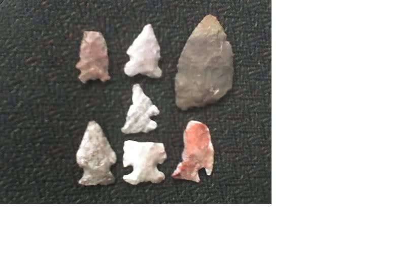
Hello all!!! Kinda new to arrowhead collecting. Was wondering if anyone could tell me anything about these arrowheads. Their age, type, etc. I have 200 acres south of Sanderson Texas and my father and I stubbled upon an Indian burnt rock midden. Around this midden we found these arrowheads on the surface of the ground. Would it be a good idea to dig inside or outside the midden? Thanks, DJ
Well, I'll take a stab at it since I'm in S.W. Texas. Left to right, the First one is too broke up for me to say. Then a Figueroa, small scraper/knife,a possible ensor, another Figueroa, a Frio, and probable castroville. All of these points range from the middle, late Archaic, and into the woodland periods. If the midden rises uniformly above 1.5 feet, it may have older materials. Putting in a test hole to original ground level will give you a better indication of what you have. Note any consistancy, changes in soils, base materials and content. This is about the only way you can determine the use lrvrl of the site. Hopefully, you will have an actual descent camp site if your not to far from water. Water is a key factor in that country. Best of Luck!
Thanks Mike. You said something about changing in the soil. In the middle of the midden the soil is black. Everywhere else is orange. We are in the desert. We actually found two middens and they are about 10 to 20 yards from an old river bed. Should there be a camp site near the middens?
DJ, I think that your further description helps me to further help you some. The area sub-grade out there should be limestone. The indians used limestone fragments to build small cooking ovens to make soltol bread and other things. The limestone will retain heat well the first time it is used, then it becomes brittle and fractures apart, usually in small cube shapes and will not retain heat well for further use. Thus, more rock is brought in, and this is why the ground surface builds up into the " midden ". As the weathered limestone gradually decomposes, it manufactures a dark " chernozem " soil. So, you clearly have a hearth at the center of the midden, and these middens clearly sound like game trail middens used only by hunting parties, and probably at times after big rainfalls, when the nearby river/creek bed was running. It would still be a good idea to put in a test hole on the outter edge from the hearth (I would choose the South or East side), and see if buried points are present.
As I said before, water availability is a key factor to finding a long term campsite in that country. With 200 Acres, I would get a copy of the USGS 7.5min. Quadrangle sheet for that area, and scan it closely for springs, especially any perrenial water sources, and look more in those areas. I have used that method in areas of Terrell County (North of Dryden), and had good luck. Happy Hunting & Merry Christmas!