Return to Website

AustinDiggers.com - Arrowhead Message Boards


THE MESSAGE BOARD POINT CHATTER IS NOW CLOSED TO ALL NEW POSTS.

 
WE HAVE MOVED TO THE NEW MESSAGE BOARD AND ALL NEW PICTURES AND POSTS WILL BE THERE FROM 4-16-2014 FORWARD.
 
THIS BOARD WILL CONTINUE TO BE HERE ONLY FOR INFORMATION AND TO READ / SEE ALL OLD POSTS.
 
GO TO AUSTINDIGGER.COM  - LOCATE THE LINK FOR POINT CHATTER II
AND LOG IN AND CHAT WITH US AND SHARE YOUR FINDS.
ALL NEW WEBSITE - ALL NEW MESSAGE BOARDS.
 
WE NOW HAVE PICTURE HOSTING !! LOG IN AND NOW YOU CAN EVEN POST YOUR PICTURES FROM YOUR PHONES - WELCOME TO 2014 HUH 8)
 
SEE YOU THERE - MICHELLE


Point Chatter - AustinDiggers.com - Arrowhead Message Board
This Forum is Locked
Author
Comment
really...........

searching the ranch i am about to be on in google maps to get my mind right for the many roads and large expanses of land thats inevitable to get lost in. i ran across this and just had to take pics of the computer screen.bear in mind there is no farmland in this area and is hard and rocky.so with that being said i guess you couldnt really call them crop circles so what would you call them. that is a location for gas and oil so did the aliens have to stop and refuel?
PhotobucketPhotobucketPhotobucket
so what do you guys ngals make of this.

Re: really...........

if you guys want to take a google map virtual drive to see this go to sterling city find 163 to barnhart go south appx 20 miles look for co. rd.126p go due west almost a straight line for about a mile and a half across 163 just before you get to jackson ln and enlarge till you see it. make sure you are on satellite.

Re: really...........

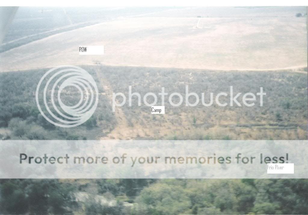
Years ago I flew over my area and took pic's of different surface anamolies from the air. I was looking for camp sites along the creeks and rivers, just curious if there would be something noticable from above. On two of the larger sites that I knew of, there was a definite alteration in vegetation.
I don't know about the football shaped one but the rectangular one looks like a tank battery. The cirlces are where the tanks sat and the lines could be the fences. We do spray ours to keep the weeds out. Still, an interesting observation from the air.
Are there any creeks in the area that you could check out and see if there's any changes? Multiple game trail crossings would be a good place for them to hunt.

Re: really...........

te. man i went back and started looking closer because your tank battery seemed right to me, but about a half a mile away is a tank battery and at the closest i could get on google you could barely even see the battery of tanks (3) the circles in the rectangle are atleast 10 times bigger. the theory is probably correct on it being some outdated and abandoned location but it still looks curiosly su****ious to me especially the big bulls eye target.

Re: really...........

On the football shaped one at both ends you can see where it's been squared off. No idea on what it is. There are different sized tanks, some upwards of 400,000 barrel tanks, used for a delivery terminal and then the oil is pipelined out. It's just a quess on what this location is. Might be interesting to drive out there and see but make sure to take some alien repellent along. They hate that stuff.

Re: really...........

These are a couple of pic's of campsites that I found, these are aerial photo's. I took them several years back when I flew around Frio co. just wanting to see if the sites would be visible from the air........and they were. Ah, a new way to find camp sites. On both pic's the river is at the bottom, on the first pic. it is visible.


Re: really...........

Couldn't find the exact Pat location , just some observations;;;
I'd say the bigger road was put through well after the ground pictographs so what ever the project was, it was before it had outside access.
The gunsight might be the location marker for the most elaborate aerial mapping ever done ( mappers usually use bedsheets laid out like a cross )

Te's top camp pic is a beauty, thats a pretty impressive bluff its on top of. Tough climb to get a drink of water.
2nd camp pic has a cleared perimeter fence line, that seems unusual out in the middle of nowhere. Took a lot of time & money to do that...some major archaeology in the past ??

While looking for the Pat site on Google map, I drifted over to the Midland Odessa area to compare oil field pictographs......WOW ......To hell with the Naska line drawings...head for Midland Odessa

Re: really...........

hey all and you too hal,the key to find this location is where co. rd. 126p dead ends into 163 go west across 163 follow the fence line about a mile and a half and there are 3 locations north of the fence and its the middle location.

Re: really...........

It was fenced in around the site. That's why the odd shape. The land owner let his family hunt there for years, then I got in his good graces and he let me out there. He fenced it in to be deer hunters out and to keep the cattle from stomping the surface finds to pieces, of which they are good at. Someone told me they thought it looked like a stock tank from the air but I told them there's no feeder creeks or windmills and ranchers don't fence in stock tanks. Still haven't figured out what the two objects are in the pasture below. Not deer blinds, and I don't recall seeing them when I went there.

Re: really...........

Those lines and shapes are actually bombing targets. If you'll look at them again they are shapes like ships, buildings, ect. We have them here in NM too. Kinda neat. I'm not positive but there are prolly shell casings and fragments scattered thoughout the area.

Re: really...........

i believe you are correct. i did some measuring on the ship looking object according to the scale offered by google maps and its around a 1000 ft long by 200 ft wide which if it were a hoax it would be quite elaborate and the target is just to precise.i do believe the locations were built after it was used as a bomb range. good call.